 †Zur¸ck
 - Schwierigkeit
- Erlebnis
- Schwierigkeit
- Erlebnis
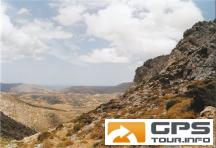
This is a hiking-track in the area of Zakros (Eastern End of Crete).
It is a nice trip along the E4 European hiking route, going up from the town of Zakros to the chapel of Ag. Gheorgios at Skalia. On the way, you can make a small detour and visit the source of Zakros river with its clear water.
You can take the same track for both ways (the provided GPX-file only covers one way), or go on from Skalia following the E4 to the town of Ziros (approx. an additional 2 hours). However, you will need to organise transport from Ziros back to Zakros.
The walk is very well waymarked with E4 signs and it is fairly easy to walk.
Take a good amount of water with you, because there is virtually no shadow on the way.
Mehr Info im WWW
 Bild 1†
 Bild 2
 Bild 3†
 Bild 4