 †Zur¸ck
 - Schwierigkeit
- Erlebnis
- Schwierigkeit
- Erlebnis
1.leg locarno - alpe foppa
start at some parking lot near locarno. Along the lake and an airfield to foot of mt. tamaro. Nice but hard to cycle ancient cobblestone road to monte ceneri. enduring dirt road up to alpe foppa.
2.leg alpe foppa - varenna
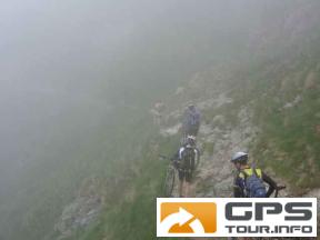
steep dirt road (some pushing) up to top of mt. tamaro. nice trail mostly driveable (watch out for biker catching bushes) later dirt road down towards lugano. Avoiding city up again on tarred road to rifugio monte bar. short after rifugio great trail starts to italian border. from there concrete road downhill to junction with tarred road. there we did hard alternative going to the left (right easier all road) following road to start of a trail. it's passing old farmer houses with loud but friendly dogs longer parts to push. finally in menaggio at lago di como, ferry to varenna.
3.leg varenna - piazza brembana
4.leg piazza brembana - lizzola
5.leg lizzola - zone
6.leg zone - lago d'idro
7.leg lago d'idro - riva
Mehr Info im WWW
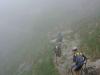 Bild 1†
 Bild 2