
 Zurück
 - Schwierigkeit
- Erlebnis
- Schwierigkeit
- Erlebnis
Date: July 26, 2010
Start: 1674 m (mountain station of Dachstein Südwandbahn / Gletscherbahn)
Finish: 1674 m (mountain station of Dachstein Südwandbahn / Gletscherbahn)
Highest point: 2033 m (Tor)
Lowest point: 1380 m
Total ascent: 900 m
Total descent: 900 m
Information about the Dachstein Südwandbahn:
href=http://www.derdachstein.at>http://www.derdachstein.at
GPX file is modified, because GPS reception between Südwandhütte and Tor was extremely bad.
**************************
Do not take anything, do not leave anything!
**************************
Please, do NOT leave trash behind. Paper tissues are also trash! Chocolate wrap as well. Bring a small trash bag with you and take your trash with yourself to the next trash can. It is not that heavy.
**************************
Mehr Info im WWW
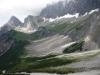 Bild 1
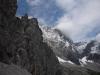 Bild 2
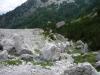 Bild 3
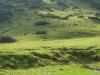 Bild 4