 †Zur¸ck

 - Schwierigkeit
- Erlebnis
- Schwierigkeit
- Erlebnis
Date: July 29, 2011
Start:1940 m (Lindlerkasa)
Finish: 1890 m (Lindlerkasa)
Highest point: 2033 m (Mohar)
Lowest point: 1840 m (Astner Moos)
Total ascent: 350 m
Total descent: 350 m
**************************
Do not take anything, do not leave anything!
**************************
Please, do NOT leave trash behind. Paper tissues are also trash! Chocolate wrap as well. Bring a small trash bag with you and take your trash with yourself to the next trash can. It is not that heavy.
**************************
Mehr Info im WWW
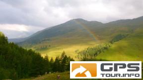
 Bild 1†
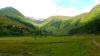 Bild 2
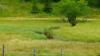 Bild 3†
 Bild 4