 Zurück
 - Schwierigkeit
- Erlebnis
- Schwierigkeit
- Erlebnis
Date: August 5, 2011
Start: 2507 m (Hochtor)
Finish: 1120 m (Heiligenblut - Rojach)
Highest point: 2671 m (shortly before Weissenbachscharte)
Lowest point: 1120 m
Total ascent: 383 m
Total descent: 1677 m
Information about the Grossglockner Hochalpenstrasse:
href=http://www.grossglockner.at/>http://www.grossglockner.at/
**************************
Do not take anything, do not leave anything!
**************************
Please, do NOT leave trash behind. Paper tissues are also trash! Chocolate wrap as well. Bring a small trash bag with you and take your trash with yourself to the next trash can. It is not that heavy.
**************************
Mehr Info im WWW
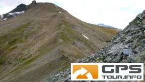
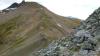 Bild 1
 Bild 2
 Bild 3
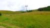 Bild 4