
 †Zur¸ck

 - Schwierigkeit
- Erlebnis
- Schwierigkeit
- Erlebnis
Samo jedno brdo, Tuhobi?, dijeli Fuûine od mora a ova staza vodit vas upravo obroncima Tuhobi?a. Kre?emo iz Fuûina i penjemo se makadamom i zemljanim putem uz predivne poglede na Fuûine i jezero Bajer sve do prijevoja na 920 m/ nm kada skre?emo u öumu. Staza ide po obroncima Tuhobi?a i prelaskom preko autoceste spuötamo se uz potok Lepenica do izlaska na staru cestu Zagreb - Rijeka. Vra?amo se ponovno na sporedne ceste, prelazimo branu i spuötamo se nazad u Fuûine.
Only one mountain, Tuhobi?, separates Fuûine from the sea and this route will take you over the slopes of Tuhobi?. We leave Fuûine and ascend along the gravel and dirt road enjoying the wonderful view of Fuûine and Lake Bajer until we reach the notch at 920 meters above sea level where we turn into the forest. The route follows the slopes of Tuhobi? and over the highway and descends along the Lepenica creek until it reaches the old state road Zagreb-Rijeka. We return to back roads, cross the dam and descent back to Fuûine.
href=http://www.bitoraj.hr>http://www.bitoraj.hr
href=http://www.adriabike.hr>http://www.adriabike.hr
Mehr Info im WWW
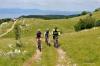 Bild 1†
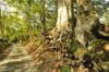 Bild 2
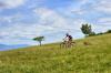 Bild 3†
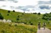 Bild 4