 Zurück
 - Schwierigkeit
- Erlebnis
- Schwierigkeit
- Erlebnis
Start and end point of the tour is the HÉV suburban railway sation of Szentendre.
From Szentendre following to 80-90% the hiking trail with yellow stripe sign to Dobogók? mountain (700m)
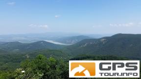
From Dobogók? following to 80-90% the hiking trail with red triangle sign to Prédikálószék mountain (great view on the Danube knee at Visegrád).
From Prédikálószék following the hiking trail with red cross sign to Pilisszentlászló.
From there a short ride on country road and then on paved bicycle road to Szentendre.
We (my 15 year old son and me (56 year old) rented two hardtail mountain bikes at Dynamobike in Budapest. We are both experienced mountainbikers. We do not recommend the tour for novices. (Difficulty is S0 to S2 very easy to intermediate with S2 difficulty only at 5-10% of the route)
Use of a GPS device is highly recommended. (Garmin etrex 30 or similar)
Wildlife: We saw many birds and one wild boar during our tour.
Eat & drink:
K?hegyi-tó mountain lake (Czibulka János K?hegyi Menedékház Restaurant) Lajos-forrás (fountain - potable water) Dobogók?(Báró Eötvös Loránd Menedékház & other restaurants) Pilisszentlászló(Kis Rigó Vendégl? Restaurant) Szentendre(many
Mehr Info im WWW
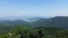 Bild 1
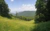 Bild 2
 Bild 3
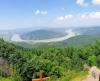 Bild 4